Table of Contents
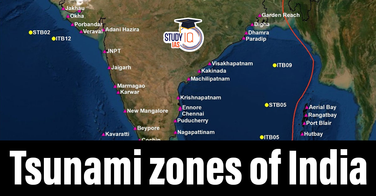
Context: As per the latest report of INCOIS, all Indian coastal Union Territories and states are prone to tsunamis.
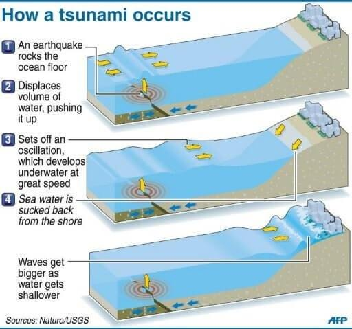
What is a Tsunami?
A tsunami is a series of large sea waves caused by the sudden displacement of a large volume of water in an ocean.
Causes of Tsunamis
- Undersea Earthquakes (most common cause)-Especially those occurring at subduction zones.
- Underwater landslides
- Volcanic eruptions (submarine volcanoes)
- Meteorite impacts (very rare).
Subduction Zone
- It is a tectonic boundary where one plate slides beneath another into the Earth’s mantle.
- Subduction zones are highly active geologically – leading to earthquakes, volcanoes and tsunamis.
Key Subduction Zones Affecting India
- Andaman-Nicobar-Sumatra Island Arc: It is a 5,000 km long chain of islands and mountains from Myanmar in the north to the Indonesian archipelago in the south.
- Makran Subduction Zone (near Iran-Pakistan): It is a tectonic plate boundary where the Arabian Sea Plate is subducting beneath the Eurasian Plate.
Tsunami Risk Classification in India (as per Geological & Oceanographic Studies)
| Zone | Risk Level |
| Andaman & Nicobar Islands | Very High |
| Tamil Nadu & Andhra Pradesh | High |
| Odisha & West Bengal | Moderate to High |
| Gujarat | Moderate |
| Maharashtra, Goa, Kerala | Low to Moderate |
| Lakshadweep Islands | Low |
| Indian National Centre for Ocean Information Services (INCOIS) |
|
Tsunami Monitoring and Preparedness in India
- Indian National Centre for Ocean Information Services (INCOIS) provides real-time tsunami alerts.
- Early Warning Systems were established after 2004.
- Community Awareness & Evacuation Drills are regularly conducted in vulnerable coastal regions.
- Coastal Regulation Zones (CRZs) aim to prevent construction in high-risk areas.
 Vizhinjam International Seaport Project,...
 Places in News for UPSC 2025 for Prelims...
 Important Lakes of India, State wise and...