Table of Contents
Context
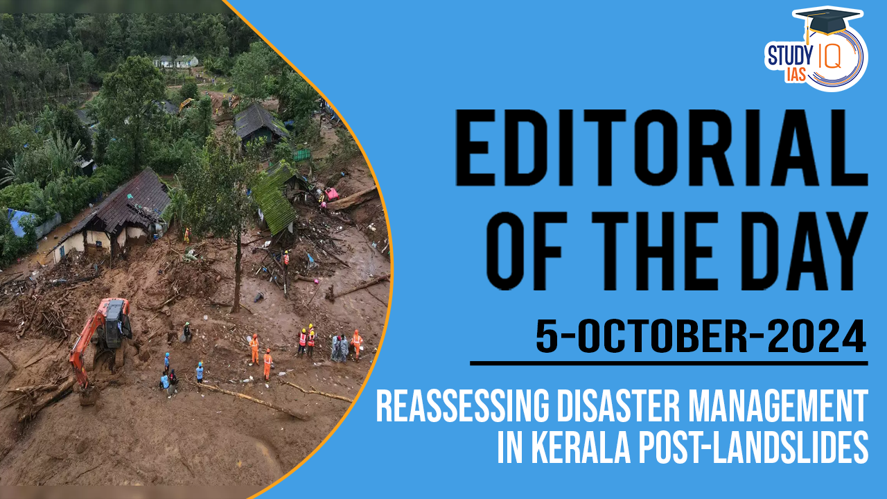
- Chief Minister of Kerala Pinarayi Vijayan stated that 231 people had died and 41 remained missing in the recent landslide in Kerala.
- The disaster exposed Kerala’s vulnerability to natural calamities and raised concerns about the state’s disaster management strategies, particularly in areas like Wayanad, which have faced landslides for over four decade
Kerala’s Changing Disaster Profile
- Kerala was historically considered a relatively disaster-free zone due to its unique geography, with the sea to its west and the Western Ghats to its east.
- Settlements and infrastructure have developed throughout the state, from the coastline to steep hill slopes, often disregarding natural drainage and slope stability.
- However, in recent decades, the frequency and intensity of disasters have increased, including floods, landslides, and coastal erosion.
- Coastal Erosion: Over 250 km of Kerala’s 590 km coastline has been affected by erosion, with sea surges also impacting different parts of the coast.
- Floods: The lowlands and midlands frequently suffer from floods, with areas around Vembanad lake inundated during the monsoon.
- The 2018 Kerala floods were described as the ‘floods of the century’ by the World Meteorological Organization, attributed to climate change.
- Landslides: The Western Ghats have experienced regular landslides during the monsoon season, especially in Wayanad and Idukki.
- The concept of a ‘safe operating space’, coined by Johan Rockstrom and the Stockholm Resilience Centre, is shrinking in Kerala.
- The increasing frequency of staggered events such as simultaneous floods and landslides (e.g., in Wayanad and Kozhikode this year, and Puthumala and Kavalappara in 2019) points to growing environmental instability.
Impact of Climate Change on Kerala
- The Arabian Sea has experienced rapid warming due to climate change, increasing the risk of extreme weather events such as floods, heatwaves, and cyclones.
- Over the last 100 years, summer sea surface temperatures have risen by 2°C in the western Indian Ocean, leading to conditions favourable for cyclogenesis (the development of cyclonic circulation).
- Kerala has experienced these changes firsthand, with Cyclone Ockhi in 2017 being one of the most severe cyclonic storms to hit the state.
What are the Needs?
- Need for Landslide Inventory Map:
- Kerala urgently needs a landslide inventory map for each region to understand areas prone to landslides. A landslide susceptibility map should be created using multiple criteria, including:
- Geological setup (lithology, structure, tectonics)
- Slope stability
- Soil characteristics
- Hydrological parameters (drainage, infiltration)
- Vegetation cover
- Human activities (mining, quarrying, agricultural activities)
- Once these maps are developed, monitoring the triggering mechanisms (rainfall and tremors) would enable timely warnings, saving lives.
- Collaboration between the state and local self-help groups would be crucial in this process.
- Kerala urgently needs a landslide inventory map for each region to understand areas prone to landslides. A landslide susceptibility map should be created using multiple criteria, including:
- Paradigm Shift in Disaster Management: Kerala’s disaster management practices are largely reactive and top-down, focusing on rescue, relief, and rehabilitation.
- A paradigm shift towards a proactive and comprehensive approach is needed, addressing all aspects of disaster cycles, including:
- Preparedness
- Resilience
- Risk reduction
- Mitigation
- Reconstruction
- Recovery
- Response and relief
- The Sendai Framework for Disaster Risk Reduction provides guidelines for this shift.
- It emphasises the role of the State in disaster risk reduction but also advocates for shared responsibility with local governments, the private sector, and communities.
- A paradigm shift towards a proactive and comprehensive approach is needed, addressing all aspects of disaster cycles, including:
Recommendations for Kerala
- Disaster Risk Zones: Kerala needs to establish disaster risk zones based on physical and social components within a social-ecological framework, using expert input and a permanent database.
- Watershed-Based Zoning: Disaster risk zones must be delineated according to watersheds or river basins, as landslides and floods often follow these boundaries.
- Community Participation: Kerala should introduce community-based disaster risk management (CBDRM), engaging at-risk communities in identifying, planning, and implementing disaster risk reduction initiatives. This would enhance communication and collaboration between communities, local governments, and the state.
- Quadruple Helix Model: A collaborative approach involving communities, academia/research institutes, government, and business/industry could facilitate better disaster management and resilience-building.
 Top 10 Richest Indians 2026 Full List Ne...
 The Transgender Persons (Protection of R...
 WASH (Water, Sanitation, and Hygiene) Se...