Table of Contents
East China Sea
The East China Sea is part of the Western Pacific Ocean in East Asia. It covers about 1,249,000 square kilometers and lies between China and Japan. It is bordered by the Korean Peninsula, China, Japan, and Taiwan. The sea connects to the Japan Sea through the Tsushima Strait and to the South China Sea via the Taiwan Strait. The northern part is called the Yellow Sea. The East China Sea is shallow and gets fresh water from the Yellow and Yangtze Rivers. Its weather is influenced by monsoon winds. The sea has several islands, including the Ryukyu Islands and the disputed Diaoyu/Senkaku Islands.
In this article, you will get to know about the details of the East China Sea in detail for UPSC/IAS exam.
Read More: India-China Border Dispute
East China Sea Countries
The countries that border the East China Sea are South
- Korea,
- Japan,
- the Republic of China (Taiwan), and
- the People’s Republic of China.
Read about: India Pakistan Border Dispute
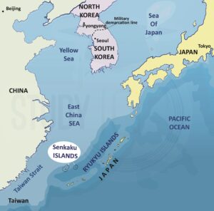
East China Sea Map
Here is a map of the East China Sea given below for a better understanding:

East China Sea Physical Geography
The physical features of South China sea are:
- The East China Sea is mostly shallow, with nearly three-fourths of it being less than 200 meters deep. Its average depth is 350 meters.
- The Okinawa Trough located next to the Ryukyu Islands, is the deepest part of the sea, reaching over 1000 meters deep with a maximum depth of 2716 meters.
- The western edge of the sea continues the shelf between the South China Sea and the Yellow Sea, while many islands and shoals are found along the eastern boundary and near the Chinese mainland.
- The shallow areas are covered with sediments mainly from the Yangtze River and other rivers, with coarser sands further out and rocks, muds, and oozes in scattered locations.
- Seismic studies show the ocean floor has nearly parallel folds and rock ridges, especially near the northern limits and the Ryukyus, which act as barriers for sediment from the Yellow and Yangtze Rivers.
- Most of the shelf is part of the stable Neo-Cathaysian Geosyncline, which is over 300 million years old, while the Okinawa Trough is about 10 million years old.
- The Ryukyu Islands have several volcanic islands, many of which are still active, and earthquakes often occur along the Okinawa Trough and the Ryukyu Island arc.
Read More: India Nepal Border Dispute
East China Sea Dispute
Directly offshore of East China is the East China Sea, an arm of the Western Pacific Ocean. It encompasses around 1,249,000 square kilometres (482,000 sq mi). The Yellow Sea, which separates the Korean Peninsula from mainland China to the north, may be found between the eastern tip of Qidong at the Yangtze River estuary and the southwestern tip of Jeju Island in South Korea.
The middle section of the first island chain off the eastern Eurasian continental landmass, which includes the Japanese island of Kyushu and the Ryukyu Islands, and the island of Taiwan, form the eastern and southeast borders of the East China Sea. Through the Korea Strait in the northeast, the Taiwan Strait in the southwest, and the gaps between the numerous Ryukyu Islands in the southeast, it is connected to the Sea of Japan, the South China Sea, and the Philippine Sea (e.g. Tokara Strait and Miyako Strait).
Nearly three-fourths of the East China Sea is shallow, with an average depth of 350 metres (1,150 feet) and a maximum depth of 2,716 metres (attained in the Okinawa Trough) respectively (8,911 ft). China, Japan, Taiwan, and South Korea all have access to the East China Sea.
Senkaku Islands
In accordance with Article 2 of the San Francisco Peace Treaty of 1951, which set the boundaries of Japan’s post-World War 2 territory, the Senkaku Islands were not part of the territory that Japan surrendered. The islands were given to the United States to manage as part of the Nansei Shoto Islands under Article 3 of the treaty. According to the 1972 Agreement between Japan and the United States of America Concerning the Ryukyu Islands and the Daito Islands, the Senkaku Islands are among the territories whose administrative rights have been returned to Japan.
China and Taiwan refer to the Senkaku Islands as the Diaoyus and Tiaoyutai, respectively. China and Taiwan both claim the islands. A group of uninhabited islands known as the Senkaku Islands in Japan, the Diaoyu Islands in China, and the Tiaoyutai Islands in Taiwan are the subject of the Senkaku Islands dispute, sometimes known as the Diaoyu Islands conflict.
In the East China Sea, there are eight uninhabited islands. They are located northeast of Taiwan and have a combined area of around 7 sq km.
Read about: Indian Ocean
China’s Claim over East China Sea
China says the islands have always been part of its territory and were important fishing grounds for Taiwan. After the Sino-Japanese War, the Treaty of Shimonoseki in 1895 gave Taiwan to Japan. China claims the islands should have been returned with Taiwan when it came back to China under the Treaty of San Francisco.
Read about: Pacific Ocean
East China Sea UPSC
China and Japan are now engaged in two related territorial disputes in the East China Sea. The Diaoyu/Senkaku Islands are at the centre of the first controversy. Japan is in charge of the islands, but China claims them. Japan does not acknowledge that a territorial dispute exists.
Read about: Indian Ocean Dipole


 Important Lakes of India, State wise and...
 Buddhism History, Origin, Sect, Councils...
 Andaman and Nicobar Islands, History, Cl...


